 Go up
Go up


Ranking the Highest Population Densities in the US
Posted on Mar 18, 2015 by Admin
Can you guess which US city has the most residents per square mile? Today we’re going to use SimplyMap to answer this question for all cities, as well as cities with a population greater than 100,000. The variable we will be using is a Census Variable, Population Density (per sq. mile), 2014.
First, create a new Ranking Report, and set the geography to USA. Next, navigate through this path to select the variable mentioned above: Census Data » In 2010 Geographies » People and Households » Population » Total.
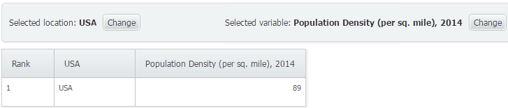
As a benchmark, the USA comes in with a density of 89 people per square mile.
To change how we analyze the variable by, utilize the Analyze Data By feature to analyze USA by States. Doing so yields the following:
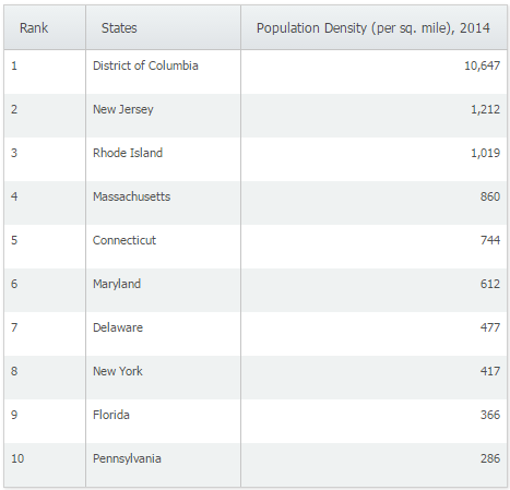
Not surprising, DC comes in first at a density of 10,647 with New Jersey coming in a far off 2nd place at 1,212. Next, we will analyze this variable by city. Unfiltered results yields the following top 10 cities:
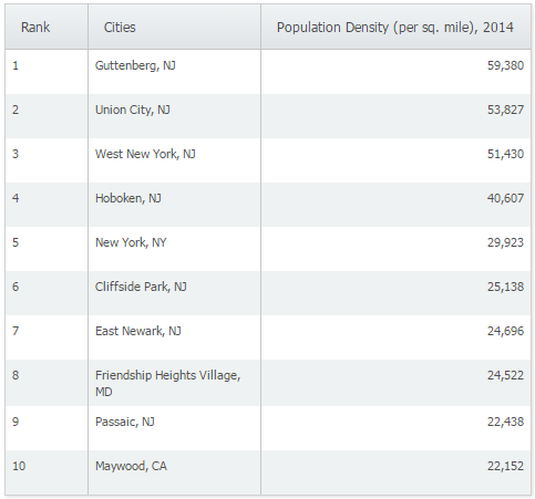
Guttenberg, NJ is the most densely populated incorporated place in the country with a staggering 59,380 people per square mile. A little research into Guttenberg, NJ reveals that the town itself is only 4 blocks wide, with a population of 11,176! It’s easy to see how Guttenberg would be ranked first overall in the United States.
Lastly, apply a population filter to only reveal cities with a population greater than 100,000. The results are shown below:
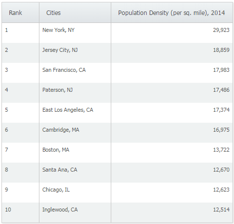
New York, NY and Jersey City, NJ rank first and second respectively as the highest population density per sq. mile for larger cities.
Are there any reports that you would personally like to see? Feel free to let us know in the comments below!
Have you already entered for your chance to win an iPad or Kindle Fire? We will be holding the drawing on April 17, 2015. To enter, simply follow us on Twitter and Like Us on Facebook to get your name in consideration.
More from SimplyAnalytics


Posted on Feb 20, 2018 by Admin
We are looking forward to attending the annual SCELC (Statewide California Electronic Library Consortium) Vendor day, at Loyola Marymount University in Los Angeles on March 8th. In additi...
Posted on Mar 13, 2023 by Admin
Hello readers! Today, we’re excited to officially introduce the Location Query Report in SimplyAnalytics. The Location Query Report is a powerful feature in SimplyAnalytics that allows us...
Posted on Sep 01, 2008 by Admin
The King County Library System in Washington State now subscribes to SimplyMap, and has published a brief review on their blog, Library Talk.
Posted on Dec 06, 2009 by Admin
ALA's Choice Magazine, publisher of independent reviews of products and services for academic libraries, released a new review of SimplyMap in the December 2009 edition. The reviewer, Car...
Posted on Sep 08, 2016 by Admin
One of our favorite uses of SimplyMap is to find data that validates our general assumptions and observations. For example, in a previous blog we wrote about the growth of tablet ownershi...
Posted on Sep 21, 2009 by Admin
The North Carolina Library Association will hold its annual conference in Greenville, NC at the Greenville Convention Center from October 6-8, 2009. Geographic Research, Inc. will be exhi...
Posted on Mar 11, 2024 by Admin
We're thrilled to announce that SimplyAnalytics will be exhibiting at the ALA Annual Conference in San Diego! We can't wait to connect with library professionals, share insights, and show...
Posted on Jan 29, 2016 by Admin
In a previous blog entry, we highlighted the benefits of having multiple years of data available for the same variable. This allows users to identify trends over time. Keeping with the sa...
Posted on Feb 01, 2009 by Admin
Want to know the top 10 wealthiest ZIP codes in your state? How about the top 25 counties with the most elderly residents? Duke University students can now easily answer these questions a...
Posted on Apr 27, 2015 by Admin
In this week’s write up we want to share some quick tips and tricks that you might not yet know about in SimplyMap. TIP #1 Did you know that you can share your work? SimplyMap allows you ...